• Home
  • About Colehill
    • Ambulance
    • Bus Services
    • Cemetery and Burial Ground
    • Colehill Community Library
      • About Us
      • Community Support
      • Activities and Events
      • Library Services
      • Supporters of Colehill Library
      • Library News
      • Books for Sale or Loan
      • Library Event Reports
    • Dentists
    • Doctors’ Surgeries
    • Fire
    • History
    • Places of Worship
    • Police
    • Pre-Schools and Nurseries
    • Schools
    • Useful Links
    • Victoria Hospital, Wimborne
  • The Council
    • Councillors
    • Meeting Dates
    • Agendas
    • Minutes
    • Governance & Policies
    • Committees
    • Council Working Groups
    • Councillors’ Roles and Representation
    • Council Finance
    • Grant Aid
    • Land Owned, Leased or Maintained by the Council
    • Planning Applications
    • Conservation
    • Our Achievements & Plans
      • Local Council Award Scheme
  • Key Initiatives
    • Biodiversity
    • Climate Emergency
      • Climate Emergency Actions
      • Free Trees for Colehill Residents
    • Cost of Living
      • Healthy Homes Dorset
    • Neighbourhood Plan
      • What is a Neighbourhood Plan?
      • Mini Surveys
    • Road Safety Matters
  • What’s On
    • Leisure Centres
    • Tivoli Theatre
    • Wimborne Tourist Information Centre
    • In-the-Village
  • Clubs & Venues
  • Young People
    • Oliver’s Park
    • St Michael’s Dirt
    • Girlguiding
    • The Reef – Colehill and Wimborne Youth and Community Centre
    • Colehill Scout group
      • Beaver Colonies
      • Scout Troops
      • Cub Packs
  • Home Watch
    • Wimborne & Colehill Home Watch
    • Home Watch Messages and Links
  • News
  • Contact
    • Contact
    • Feedback
MENU
Skip to main content
Colehill Parish council logo
Search
Our Email:clerk@colehill.gov.uk
Our Facebook page Our Twitter page
  • Home
  • About Colehill
    • Ambulance
    • Bus Services
    • Cemetery and Burial Ground
    • Colehill Community Library
      • About Us
      • Community Support
      • Activities and Events
      • Library Services
      • Supporters of Colehill Library
      • Library News
      • Books for Sale or Loan
      • Library Event Reports
    • Dentists
    • Doctors’ Surgeries
    • Fire
    • History
    • Places of Worship
    • Police
    • Pre-Schools and Nurseries
    • Schools
    • Useful Links
    • Victoria Hospital, Wimborne
  • The Council
    • Councillors
    • Meeting Dates
    • Agendas
    • Minutes
    • Governance & Policies
    • Committees
    • Council Working Groups
    • Councillors’ Roles and Representation
    • Council Finance
    • Grant Aid
    • Land Owned, Leased or Maintained by the Council
    • Planning Applications
    • Conservation
    • Our Achievements & Plans
      • Local Council Award Scheme
  • Key Initiatives
    • Biodiversity
    • Climate Emergency
      • Climate Emergency Actions
      • Free Trees for Colehill Residents
    • Cost of Living
      • Healthy Homes Dorset
    • Neighbourhood Plan
      • What is a Neighbourhood Plan?
      • Mini Surveys
    • Road Safety Matters
  • What’s On
    • Leisure Centres
    • Tivoli Theatre
    • Wimborne Tourist Information Centre
    • In-the-Village
  • Clubs & Venues
  • Young People
    • Oliver’s Park
    • St Michael’s Dirt
    • Girlguiding
    • The Reef – Colehill and Wimborne Youth and Community Centre
    • Colehill Scout group
      • Beaver Colonies
      • Scout Troops
      • Cub Packs
  • Home Watch
    • Wimborne & Colehill Home Watch
    • Home Watch Messages and Links
  • News
  • Contact
    • Contact
    • Feedback
Search
clerk@colehill.gov.uk

New Parish Map Display

November 2018

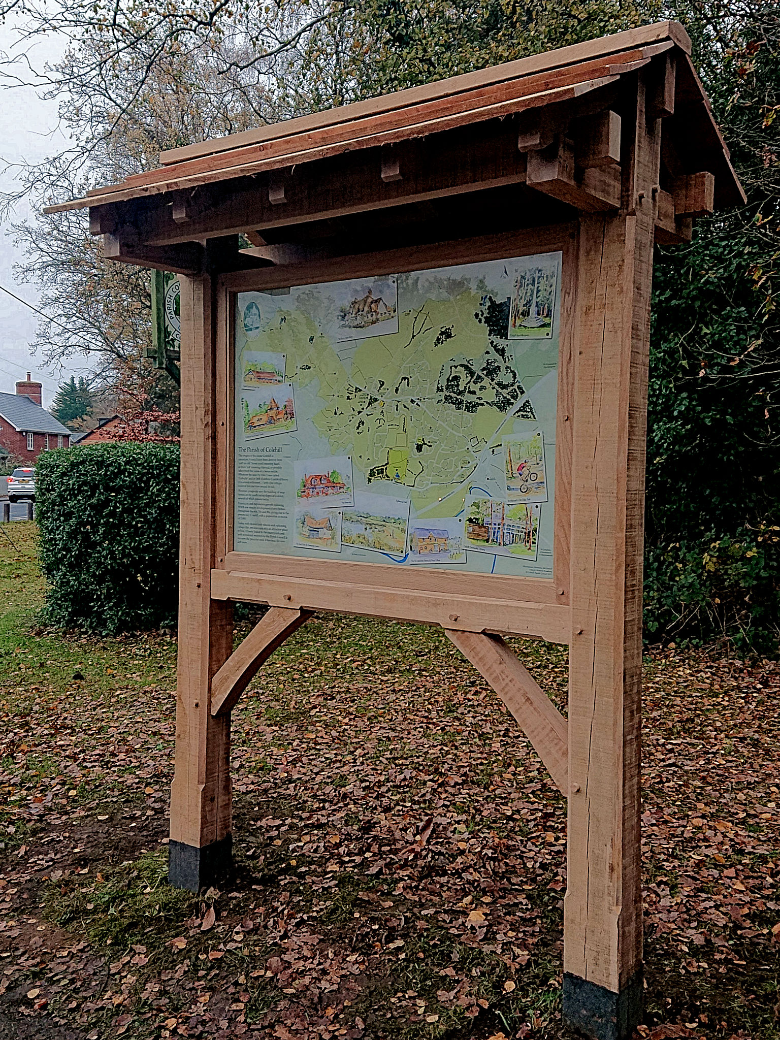
Colehill Parish Council’s new map display board has been erected on the green opposite the Co-Op in Colehill. This is the culmination of a project begun in June 2017 after the previous map display board “The Colehill Millennium Map” had been vandalised. While the Millennium Map had been designed to record the village as it existed at the end of the 20th century, it was recognised that people – residents as well as visitors – would often consult the map for directions and understanding of the village layout and its facilities. The new map is designed to provide current, useful information and to be updated – in time – as things change.

The map itself is directly printed (@1260 x 900mm) onto the reverse of a perspex sheet, so as to avoid any issues with condensation, dirt, mould, vegetation or insects which might otherwise encroach between separate layers. Although the shape and composition of the village may change over the next 100 years it should be a relatively straightforward process to be able to update and reprint the map.

The design is by Richard Broadway and is based on a satellite image, which was then then extensively customised, over several weeks, with the addition of street names, footpaths, boundaries, parks and places of interest. The illustrations are by Rosemary McDonald and the construction and erection of the oak frame and canopy is by Colehill craftsman Nigel Harris. Over £700 of part air-dried and fully air-dried English Oak (provided by a local sawmill from responsibly managed resources) is used in the structure, while the roof boards are of Western Red Cedar. Nigel suggests that, properly maintained, the oak should last 100 years, although the roof boards will need replacing after 30 or 40 years.

The Parish Council have erected a copy of the map in the committee room at Colehill Memorial Hall for reference during council meetings and residents are already asking about copies for their own walls.  Consideration is also being given to making copies of Rosemary’s lovely illustrations available to raise money for charity.

Tagged:
Map


Accessibility Statement
Our email address: clerk@colehill.gov.uk
Our Facebook page: @colehillpc
© Colehill Parish Council 2025
Parish council theme by WD4D